9 Planimetric features
Description hierarchy
Transfer file
|
| Units (Metric) |
| Coordinate and elevation system |
| Base point |
| Project |
"IM_codings" extension
type coding systems |
| Application |
| Authors |
| Collection of planimetric features |
| Planimetric feature such as building footprint, guard rail, lightpole or signage |
| Plan feature geometry |
| Line (geom. line) |
| Line string |
| Circular arc (geom. line) |
| Transition curve (geom-line) |
| Plan feature location |
"IM_cable" extension
cable plan feature details |
"IM_footing" extension
footing plan feature details |
"IM_railing" extension
railing plan feature details |
"IM_fence" extension
fence plan feature details |
"IM_surfaceStructure" extension
surface structure plan feature details |
"IM_planfeature" extension
generic plan feature details |
"IM_coding" extension
planfeature type coding |
"IM_coding" extension
planfeatures collection type coding (infra coding) |
"IM_plan" extension
plan information |
| Definition dictionary of extensions |
9.1 Contents
In an Inframodel file, any plan contains the header information described in the section 1. The design content in the file is defined in metric units, using an
adequate number of decimals for accuracy. For example, when the length unit in use is meter, the values must be defined to at least six decimal places.
Planimetric features, such as cables, lightpole or signage footings, railings and fences, or any other objects not otherwise defined by LandXML schema are described using <PlanFeature> element. These features often interface with route (road, street, rail or waterway), in which case they are described under <Roadways> collection in the same file, as defined in chapters 4, 5 and 6. This chapter covers those planimetric features not directly assigned to any particular route, and surface structures potentially spanning across multiple routes (such as urban street surface plans).
9.2 Plan features
The planimetric features not directly assigned to any particular route (road, street, rail or waterway) are grouped in planimetric features collections under <PlanFeatures> consisting of several <PlanFeature> elements. How the planimetric features are arranged into collections (e.g. by types) is subject to project guidelines or other usage agreements. Each collection shall have a unique name.
Attributes of <PlanFeatures>:
 |
desc |
description |
e.g. [Steel mesh fences type T2] |
 |
name |
unique name |
e.g. [A_fences_T2] |
|
state |
state
|
[abandoned]
[destroyed]
[existing]
[proposed] |
Planimetric features collections may be also be type coded in <Feature> using 7. Type coding in "IM_coding" extension. In particular, this should be used when the collections contains surface structrure definition associated with the topmost surface of a plan: [InfraCoding] set to value [201000]
 |
|
<PlanFeatures> |
schema documentation |
9.2.1 Plan feature
The individual plan features are each described under <PlanFeature>, having a mandatory and unique name and optionally <Location> and geometry as <CoordGeom>.
Attributes of <PlanFeature>:
|
desc |
description |
e.g. [Steel mesh fence] |
|
name |
unique name |
e.g. [f_123] |
|
state |
state
|
[abandoned]
[destroyed]
[existing]
[proposed] |
<PlanFeature> geometry is described in <CoordGeom> using line strings for linear features, e.g. cables, railings and fences; in case of sruface structure boudaries, also circular or spiral curve arcs may be used. For point features, such as footings, location is given in <Location> element as a two or three dimensional point:
<Location>northing easting (elevation)<Location>
|
|
<PlanFeature> |
schema documentation |
Details of <PlanFeature> are described as <Feature> extension, defined for each type as follows:
Additionally, all plan features may be type coded in <Feature> using 7. Type coding in "IM_coding" extension.
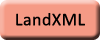
9.2.1.1 Cable
Details of <PlanFeature> in "IM_cable" <Feature>
 |
|
Cable |
example |
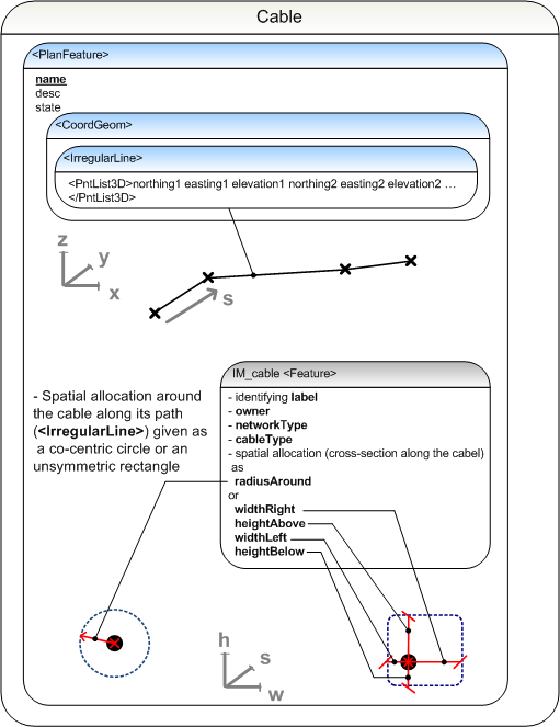
9.2.1.2 Footing
Details of <PlanFeature> in "IM_footing" <Feature>
|
|
Footing |
example |
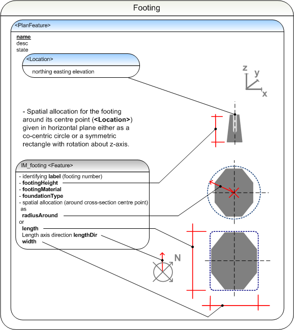
9.2.1.3 Railing
In Inframodel, this type of planfeature covers guardrails and guide bars, as well as touch, bump and collision protection structures.
Details of <PlanFeature> in "IM_railing" <Feature>
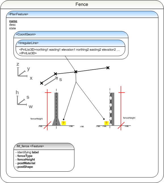
9.2.1.4 Fence
In Inframodel, this type of planfeature covers fences, booms and barriers, as well as gates and openings such as fence manholes.
Details of <PlanFeature> in "IM_fence" <Feature>
9.2.1.5 Surface structure
In Inframodel, this type of planfeature covers surface structure properties (material, thickness).
Details of <PlanFeature> in "IM_surfaceStructure" <Feature>
|
|
Surface Structure |
example |
9.2.1.6 Generic feature
When no specific <Feature> extension defined above can be applied, these generic definitions can be used.
Details of <PlanFeature> in "IM_planfeature" <Feature>
9.2.1.7 Type coding
Coding of <PlanFeatures> in "IM_coding" <Feature>:
|
name |
optional name |
e.g. [10] |
|
code |
code |
[IM_coding] |
|
source |
source |
[inframodel] |
|
label |
[infracoding] |
type code of the plan feature
|
value |
e.g. [3225] |
|
label |
[infracodingDesc] |
type code description
|
value |
e.g. [Gates] |
|
label |
[proprietryInfraCoding] |
additional or alternative infra type code |
value |
code
e.g. in system by organisation Y [y:322502] |
|
label |
[proprietaryInfraCodingDesc] |
description of additional or alternative type code |
value |
description
e.g. [y:Double swing gate] |